Sommet Bucher
Mainly a woodland, do not fall for the monotony of the place. Some places make us instantly switch to another world or a different era. This is the case here. The Clot Henri (cabins) gives us a little paradise out of nowhere if not from a tale for children. As for the Col des Prés de Fromage, it brings us back to the Middle Ages: a wooden fountain, cows, a panorama of the settings, the lower Guil and the valley of l'Aigue Blanche welcome us! Refreshed by these changes of scenery, the descent will seem light and smooth.
6 points of interest

Centaurée des montagnes - Benjamin Musella - PNR Queyras  Flora
FloraPerennial cornflower
This variety of cornflower grows in cool and sparse forests and meadows. It lives in more or less important colonies and grows through underground stolons. Loving the freshness especially, this plant can survive up to -15 °C / 5 °F. It houses and serves as food for caterpillars and aphids. If pollination is done through different insects, bumblebees predominate this flower.
Chevreuils - Alain Bloc - PNR Queyras  Fauna
FaunaRoe deer
From February to August, the male has a particular behaviour. He rubs his antlers on young tree shoots which he bares completely. In winter, this action aims to remove the velvet-like fur covering the new antlers. But at the time of the rut, this action is to place a secretion coming from the glands located at the base of the antlers, a very fragrant substance that helps in marking his territory. It's called rubbing. The other marking technique involves scraping the ground to prepare the den. This is called scraping. When both behaviours occur, it's called fraying.
Syrphe - Benjamin Musella - PNR Queyras  Fauna
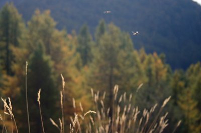
FaunaHoverflies
Often confused with wasps, hoverflies are diptera (a single pair of wings). They have the distinction of having sharp changes in direction, and to practice hovering. They are harmless and very useful. The larvae feed on aphids and protect gardens. As for adults, they feed on pollen and nectar. They play an important role in pollination. Their presence is evidence of biological and ecological wealth. These are very fine quality and environmental diversity indicators. Inventories help to guide management, especially forestry, as it was developed in the National Nature Reserve of Lake Remoray in the Doubs and Jura.
Vue depuis le sommet Bucher - Benjamin Musella - PNR Queyras  Panorama
View from the Sommet Bucher
From the top looking towards the valley of Aigue Blanche. In the foreground, the Pic de Château Renard serves as the junction with Aigue Agnelle. At the back, the Tête de Toillies, the Pic de la Farneiréta, the Tête de Longet, the Roche Noire, the Peouvouand and others mark the border with the Ubaye. The Sommet Bûcher offers views on the lower Guil, the upper Guil, the Ecrins massifs and the Arvieux valley.
Guépinie rousse - Benjamin Musella - PNR Queyras  Flora
FloraApricot jelly or Salmon salad fungus
This fungus is gelatinous, funnel-shaped, translucent and smooth. Gradually, its top rolls and turns into a gutter-shaped foot. It grows in the mountains, between resinous trees and enjoys wetlands. Although it is edible, it is a bland fungus.
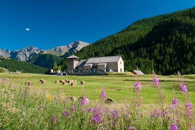
Eglise Saint-Romain - Images et Rêves  Patrimony and history
Saint-Romain Church
The church is composed of a single nave and 4 rows with a vault in tuff. Its bell tower of 10m high was imagined as a defensive tower. In 1575, it served as a shelter during the religious wars. Protestants turned it into a prison and trapped and tortured community leaders saidto be devouts Catholic. Between 1628 and 1637, the church was rebuilt and an additional row was added to accommodate the growing number of Catholics in the Queyras following the revocation of the Edict of Nantes.
Description
From the parking lot, go down the road and reach the point: Molines, below le Serre. Go down to the left on a track and cross the stream on a wooden bridge and turn right.
1 - Go up a track on a hundred metres or so and turn right, follow the trail which becomes steeper then quickly becomes smooth when near a picnic table and a nice view of the valley of Aigue Blanche. Continue the broad false flat track.
2 - At the intersection of the woods of Eyssard (2 034m), turn left towards the Clot Henri. Reach the Clot Henri, cross it and follow the trail that leads to the exit of the forest, 10m below the Col des Près de Fromages.
3 - At the mountain pass, turn right and follow the wide path that roughly goes along the ridge, reach onto a track, turn right and rach the Sommet Bucher quickly. The return is by the same route until you reach the intersection of the woods of Eyssard.
4 - Turn left and descend rapidly right into the Rif de Sainte Colombe. Reach on a track, turn right and continue on this track. Cross the stream of Aigue Blanche and go to the village.
5 - The track becomes a road, go straight, go through the village leaving the Saint-Romain church on the right and reaching the D5. Follow this road towards Saint-Véran to regain the car park of the starting point 300m further.
- Departure : Molines-en-Queyras
- Arrival : Molines-en-Queyras
- Towns crossed : Molines-en-Queyras and Château-Ville-Vieille
Forecast
Altimetric profile
Information desks
House of the Queyras Regional Nature Park
3580 Route de l’Izoard, 05350 Arvieux
The House of the Queyras Regional Nature Park is closed to the public.
OTI du Guillestrois et du Queyras
Maison du Tourisme du Queyras, 05350 Château-Ville-Vieille
Transport
05 Voyageur: 04 92 502 505 Tourist Office of Queyras: 04 92 46 76 18
Access and parking
Follow the D5 to Molines-en-Queyras. Continue towards Saint-Véran. Pass the first intersection on the right, the point Molines, below le Serre.. Park a few metres away to the left.
Parking :
More information
Report a problem or an error
If you have found an error on this page or if you have noticed any problems during your hike, please report them to us here:


