Furfande on mountain bike
Very nice tour in a loop with a long ascent on a forest track and a long technical descent which starts from the alpine meadows to finish in undergrowth.
5 points of interest
 Flora
FloraLinaria alpina
Also known as alpine toadflax, the Linaria alpina likes hostile and poor environments. It is found in high mountain screes or gravel pits. It is perennial and blooms from June to September. Panorama
View from the Col de Furfande (mountain pass)
View from the Col de Furfande on the Arvieux valley. In the back we see the mountain passes of Izoard, Arpelin and Lasseron. On the right, the peak of Côste Belle hides in the clouds. In the foreground, to the right, the Crête de la Plate plays hide and seek. Patrimony and history
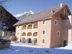
Furfande mountain chalets
The first written proof of use of these pastures dates back to the 15th century. At the time, the place was a dependency of the Boscodon abbey. Residents of Escoyères stored their hay and brought them down on the backs of mules. In 1628, the well developed village of Arvieux sought lands to expand its production. The pasture is bought and residents of both villages share the summer pastures. The cottages have a ground floor in stone and a wooden first floor without a balcony for drying purposes. Fauna
FaunaArion ater
Also known as the Black Slug, this large slug is present in multiple areas but especially in the mountains. It measures between 10 and 15 cm but can reach 20 cm exceptionally. The different individuals have very different colourations. You can see slugs which are black, red-orange and rarely gray or white ones. Flora
FloraThe larch forest
The larch forest is a typical habitat of the Southern Alps. It is maintained by regular consumption of undergrowth by sheeps. Without this maintenance, it would have slowly and permanently been replaced by pines. This tree is periodically attacked by a butterfly: the larch budmoth. Every 6 years, it transforms green landscapes in autumnal sceneries. Rest assured, after consumption of the bases of the needles, the larches recover their soft colours, this year or the next.
Description
Exit the parking lot, turn left and quickly to the right at a fountain. Cross the bridge, turn left and then right before the second bridge.
1 - Ride up the stream of the Champ la Maison on a good forest track. Continue on the main track to the Col de Furfande.
2 - Pass the collar and go down by a smooth single track which connects to the refuge de Furfande. At the refuge, take the left trail, easy to ride but a little rocky until the Col de la Lauze.
3 - After the mountain pass, turn left on a more technical trail with a few aerial parts and steps. Beware of the cow pens, they may exit from a corner and not be seen until the last minute. Keep on the left and reach the chalets of Queyron. Go between the chalets and reach a track.
4 - Turn right and follow the trail that leads to a picnic area.
5 - At the sign Clôt la Chalp, turn left towards Arvieux. Cross an enclosed plot and enter the forest. Take a smooth path mostly descending 6 - When you reach the forest track, turn left and follow the direction of Fontouse. Leave the track a little after the stream of Fontouse and take the path on the right. Continue until a bridge, cross it and turn right to find Arvieux.
- Departure : Arvieux
- Arrival : Arvieux
- Towns crossed : Arvieux
Forecast
Altimetric profile
Information desks
House of the Queyras Regional Nature Park
3580 Route de l’Izoard, 05350 Arvieux
The House of the Queyras Regional Nature Park is closed to the public.
OTI du Guillestrois et du Queyras
Maison du Tourisme du Queyras, 05350 Château-Ville-Vieille
Transport
05 Voyageur: 04 92 502 505 Tourist Office of Queyras : 04 92 46 76 18
Access and parking
Take the D902 to Arvieux. Park at the car park of the Tourist Office.
Parking :
Report a problem or an error
If you have found an error on this page or if you have noticed any problems during your hike, please report them to us here:


